Niaodiaoshan Alpine E-MTB Trail: Dali Guided Riding Guide
An 18 km alpine E-MTB trail on Mount Niaodiao near Dali, ridden between 2,880 m and 3,242 m. Terrain by section, gear, seasons, transfers and what a guided day includes.
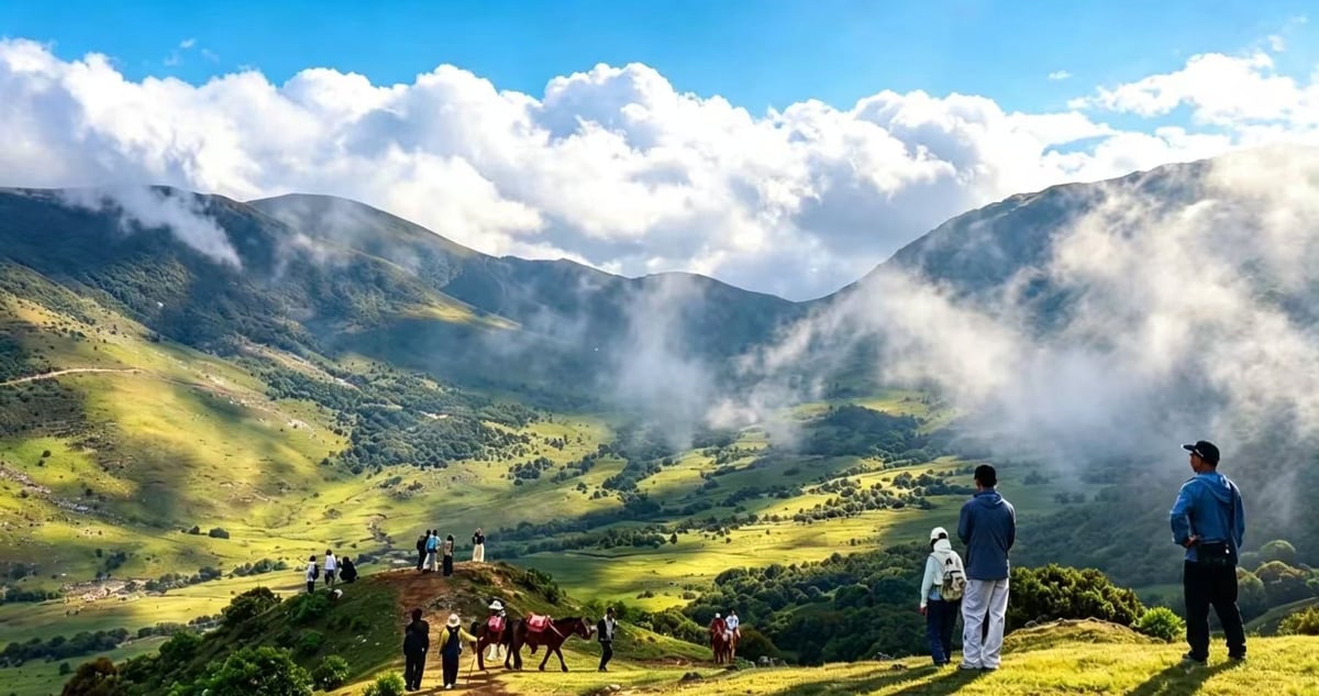
Mount Niaodiao sits northwest of Dali Ancient City in Eryuan County, and it is the rare high-altitude off-road ride that a beginner can genuinely enjoy. Eighteen kilometres of forest track, meadow and lakeside path between 2,880 and 3,242 metres, with only about 400 metres of climbing — and a high-torque mid-drive e-MTB doing the part of the work that altitude would otherwise make miserable.
That combination is the whole point of the route. Without electric assistance, riding at 3,000 metres on loose dirt is a fitness exercise. With it, it becomes a landscape day: coniferous forest, open ridgeline, alpine lakes and long views, at a pace that leaves you able to look at them. Our team last rode and checked the trail on 10 August 2026.
Before you ride
Quick answers
Is this suitable for beginners?
Yes. The electric assist handles the 400 m of climbing; you need basic balance and braking on dirt, nothing more.
How high does it go?
3,242 m at the high point, starting from around 2,880 m.
How long is the day?
3–4 hours riding, about 5 hours in total with transfers, briefing and photo stops.
Do I need my own bike?
No. DJI Amflow e-MTBs, helmets, knee pads and gloves are provided on site.
Route Overview
Mount Niaodiao spans several habitats in a short distance — high-altitude coniferous forest, dense shrubland, open meadow and alpine lakes — and the trail moves through all of them on unpaved dirt track and singletrack. Because the base of the ride already sits above 2,800 metres, a high-torque mid-drive e-MTB is what makes the 400 metres of climbing feel like nothing, and lets riders of very different fitness levels stay together as a group.
The route runs point to point: start at the DALIENDURO Club, finish at a valley road junction near Eryuan where the support van collects riders and bikes for the return to Dali Ancient City North Gate.
Route Breakdown
Section 1: Forest ascent to the high meadows — approx. 7 km
Unpaved forest trail and dirt track. The ride opens with a safety briefing and e-bike orientation — worth taking seriously if you have never used a mid-drive assist system, because the power delivery on loose dirt is not intuitive at first. From there it is a steady climb through high-altitude pine forest that gradually opens into alpine shrubland.
Section 2: Ridge and lake circuit — approx. 6 km
Grassland track and dirt paths around alpine lakes. This is the scenic core of the day: open ridgeline riding up to the high point near 3,242 m, meadow trails beside the lakes, and the best drone and photography positions on the mountain.
Section 3: Descent to the transfer junction — approx. 5 km
Unpaved forest singletrack and dirt roads, descending under control to the valley road junction near Eryuan where the van waits. Nothing technical, but loose surface descending is where inexperienced riders make mistakes — keep spacing between bikes.
Distance, Elevation and Difficulty
Eighteen kilometres and 400 metres of climbing is modest by any measure. What is not modest is the altitude: the trail starts at 2,880 m and peaks at 3,242 m, where the air is noticeably thin for anyone arriving from sea level.
The route is rated introductory precisely because of the bikes. A powerful mid-drive e-MTB flattens the climbs that would otherwise make this an intermediate ride at altitude. Technically it asks only for basic bike control — braking on dirt, cornering on loose soil. There is no rock garden and no committed downhill section.
Surface and Traffic
- Surface: 100% natural and unpaved — forest soil, grass, fine gravel and dirt track.
- Wet conditions: rain turns sections of soil and meadow slick and muddy. Speed control matters more than line choice.
- Traffic: the entire route is on forest trail and dirt road isolated from public motor traffic. You may meet livestock or a farm vehicle near pasture.
Who Is This Ride For?
Recommended for
- Beginner to intermediate off-road riders
- Recreational riders and outdoor photographers who want alpine terrain without the suffering
- Mixed-ability groups — the assist is what keeps everyone together
Prerequisites: basic balance and braking on unpaved dirt.
Not suitable for
- Children
- Anyone with severe cardiovascular conditions or a history of acute altitude illness
- Riders looking for technical downhill singletrack
If you want the harder version of a Dali mountain day, Zhemo Mountain is the more technical ride, and our shorter Niaodiao Mountain overview covers the same area from a scenery-first angle.
Recommended Bike and Gear
- Bike: e-MTB with a high-torque mid-drive motor. DJI Amflow rental units are provided on location.
- Safety gear: helmet, knee pads, and full- or half-finger gloves — included free on guided trips.
- Footwear and clothing: flat-soled athletic or hiking shoes with grip; layered outdoor clothing including a windproof shell and a thermal base layer.
- Sun protection: high-SPF sunscreen, UV sunglasses and lip balm. Above 3,000 m the UV load is severe even on cool days.
Resupply and Pacing
- Water: carry it. There is nothing to buy on the mountain — backpack reservoir or frame cage, filled before you start.
- Food: a local picnic lunch (firewood-stewed chicken is the local speciality) can be reserved in advance for an additional fee.
- Pacing: steady cadence on the climbs, generous spacing on the dirt descents.
Best Season and Weather
- Optimal months: June through October, when the meadows are green and the wildflowers are out.
- Weather risk: mountain weather turns fast. Rainstorms arrive suddenly, drop the temperature, and make the dirt slick. Exposed ridgelines get strong wind in the morning and late afternoon.
- Cold: it is significantly colder at 3,200 m than in Dali Ancient City. Pack a windproof layer even on a clear day.
Navigation and Safety
- Navigation: guided rides include a lead cyclist handling route finding; GPX tracks are available for verification.
- Mobile coverage: intermittent across the high-altitude section. Offline maps or a guide are strongly recommended.
- Descending: fingers on the levers, speed under control on loose dirt.
- Insurance: riding insurance is included with guided service packages.
- Evacuation: vehicle access is limited to designated trail junctions. If weather, fatigue or a mechanical ends the ride early, the support van meets riders at pre-agreed connection points.
Riding It With CycleQuest China
Guided — recommended for international visitors. Packages can include round-trip van transfer from Dali Ancient City, e-MTB rental, safety gear, photo and drone coverage, insurance, and an English-speaking guide as a paid add-on.
Self-guided. Riders with their own transport, high-altitude trail experience and GPX navigation can ride independently, provided they bring proper off-road equipment and rain gear.
See Dali bike rentals for the fleet, our Dali cycling tours for multi-day itineraries that include the mountain, or send a rental request with your dates.
FAQ
Is the Mount Niaodiao trail suitable for total beginners?
Yes. The electric assist makes the 400 m of climbing manageable for beginners. You need basic balance on unpaved dirt paths, nothing more.
What is the highest elevation on this trail?
Approximately 3,242 metres above sea level.
Are helmets and protective gear provided?
Yes. Standard rentals include a helmet, knee pads and riding gloves at no extra charge.
Can an English-speaking guide be arranged?
Yes, on request, as an optional paid service.
How do riders get to the trailhead from Dali Ancient City?
Round-trip van transport from Dali Ancient City North Gate can be reserved as part of the guided package.
What happens if it rains?
The trail becomes muddy and slippery in heavy rain. The trip leader assesses conditions on the morning of the ride and will adjust or reschedule where safety requires it.